
An inertial positioning system becomes valuable when a machine must maintain a reliable estimate of its position and orientation while moving through changing environments.
In robotics, aerospace platforms, and autonomous vehicles, satellite positioning alone may not provide continuous information because signals can be obstructed, interrupted, or temporarily unreliable. Combining inertial measurements with GNSS creates a more resilient spatial reference for control, navigation, and automation.
For engineers, the important question is not simply whether inertial technology can locate a platform. It is where the technology adds value, how it is integrated, and what level of continuity the application requires.
Robotics: Maintaining Spatial Awareness During Motion
Mobile robots operate in environments where movement is continuous and surroundings can change quickly. Warehouse vehicles, inspection robots, unmanned surface vessels, drones, and industrial machines may need position, heading, velocity, and attitude information at the same time.
An inertial positioning system combines measurements from inertial sensors with external positioning references. Gyroscopes and accelerometers measure angular motion and acceleration, while GNSS can provide an absolute geographic reference when satellite signals are available. Sensor fusion uses these complementary sources to maintain a more useful navigation state.
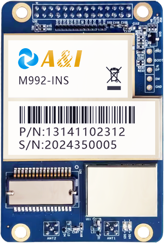
The M992-INS is designed for multiple platforms, including low-speed vehicles, drones, unmanned surface vessels, and port or mining vehicles. Its manufacturer describes it as a dual-antenna tightly coupled GNSS-INS board capable of providing positioning and orientation information at high output rates.
Aerospace: Linking Position, Attitude, and Timing
Aerospace platforms place particular emphasis on knowing both location and orientation. A drone performing aerial mapping, inspection, or surveying needs more than a basic geographic coordinate.
Its flight-control and payload systems can require synchronized information describing where the aircraft is, how it is oriented, and when each measurement occurred.
A dual-antenna architecture can contribute directly to heading determination. The M992-INS specifies dual-antenna GNSS observation and position-and-heading outputs, while its inertial subsystem supplies high-rate raw and fused observations. The published specifications list INS raw and fusion output frequencies of up to 1000 Hz.
Timing is another reason integrated navigation hardware matters in aerospace sensing. The M992-INS supports PPS, NTP, and PTP synchronization. Its product documentation specifies positioning‑and‑orientation fusion output at 200 Hz, with raw INS inertial observations available at up to 1000 Hz maximum. Such interfaces can help coordinate navigation information with other onboard systems, subject to platform requirements.
Aerial mapping and inspection are explicitly listed among the M992-INS application areas. That makes an integrated navigation architecture particularly relevant to unmanned aircraft that need consistent spatial information while collecting georeferenced data.
Autonomous Driving: Supporting Continuous Vehicle Localization
Autonomous vehicles require a spatial reference that remains useful as the vehicle accelerates, turns, encounters uneven surfaces, or enters environments where satellite reception is degraded. Positioning therefore becomes one component of a broader vehicle-state estimation architecture.
Here, a navigation board can connect GNSS and inertial measurements with the vehicle’s electronic systems. The M992-INS provides CAN and Ethernet interfaces alongside serial connections, supporting integration with controllers and other onboard equipment. Its product documentation also identifies autonomous driving as a target application.
The value of inertial sensing becomes clearer during short periods when GNSS measurements are unavailable or compromised. Rather than treating satellite positioning as the only source of movement information, sensor fusion uses inertial measurements to continue estimating the vehicle state.
The published M992-INS specifications list dead-reckoning accuracy of 0.2% for 1 km travel within a 3‑minute GNSS‑outage window, as its official published performance metric.
What Determines the Right Inertial Architecture?
Application requirements should determine the sensor configuration rather than the other way around. Engineers need to define expected positioning accuracy, heading requirements, GNSS availability, motion dynamics, environmental conditions, interfaces, synchronization needs, and physical constraints before selecting hardware.
Dual-antenna GNSS can be valuable when heading information is required without depending solely on motion-derived heading. Inertial sensors then provide high-rate measurements that complement the satellite reference. Tightly coupled processing can combine these measurements within a unified navigation solution.
The choice of a navigation board also affects system integration. Interfaces, output frequency, timing support, enclosure characteristics, sensor compatibility, and configuration methods can influence development effort as much as raw positioning specifications.
Archimedes Innovation’s M992-INS supports external high-performance IMU devices and L-band satellite-based augmentation signals, according to its published product information. The board also includes an embedded web interface for querying and configuration, features intended to simplify integration and deployment across different platforms.
Turning Navigation Data Into Machine-Level Decisions
Across robotics, aerospace, and autonomous driving, the role of an inertial positioning system is ultimately to provide dependable state information that another system can use. It does not replace perception, path planning, or vehicle control. Instead, it supplies a spatial and motion reference that those functions can build upon.
Robots use it to maintain awareness while moving, aerospace platforms use it to associate position with attitude and timing, and autonomous vehicles use it to support continuous localization and control.
In each case, the strongest architecture comes from matching GNSS, inertial sensing, communications, and computing to the platform’s real operating conditions.
Archimedes Innovation positions the M992-INS for autonomous driving, maritime navigation, machine control, aerial mapping and inspection, and other platforms where integrated positioning and orientation are required.
For system integrators, that application range highlights the main design principle: inertial navigation is most useful when engineered as part of the complete autonomy stack rather than treated as an isolated sensor.
